National Hurricane Center Graphical Tropical Weather Outlooks
National Hurricane Center Graphical Tropical Weather Outlooks- NHC Atlantic Outlook
-
NHC Eastern North Pacific Outlook
ZCZC MIATWOEP ALL
TTAA00 KNHC DDHHMM
Tropical Weather Outlook
NWS National Hurricane Center Miami FL
500 PM PDT Mon Jun 16 2025
For the eastern and central North Pacific east of 180 longitude:
Active Systems:
The National Hurricane Center is issuing advisories on Potential
Tropical Cyclone Five-E, located in the eastern Pacific basin off
the coast of Guatemala.
* Formation chance through 48 hours...high...near 100 percent.
* Formation chance through 7 days...high...near 100 percent.
&&
Public Advisories on Potential Tropical Cyclone Five-E are issued
under WMO header WTPZ35 KNHC and under AWIPS header MIATCPEP5.
Forecast/Advisories on Potential Tropical Cyclone Five-E are issued
under WMO header WTPZ25 KNHC and under AWIPS header MIATCMEP5.
$$
Forecaster Gibbs/Cangialosi
NNNN
-
CPHC Central North Pacific Outlook
ZCZC HFOTWOCP ALL
TTAA00 PHFO DDHHMM
Tropical Weather Outlook
NWS Central Pacific Hurricane Center Honolulu HI
Issued by NWS National Hurricane Center Miami FL
200 PM HST Mon Jun 16 2025
For the central North Pacific...between 140W and 180W:
Active Systems:
The National Hurricane Center is issuing advisories on Potential
Tropical Cyclone Five-E, located in the eastern Pacific basin off
the coast of Guatemala.
* Formation chance through 48 hours...high...near 100 percent.
* Formation chance through 7 days...high...near 100 percent.
Tropical cyclone formation is not expected during the next 7 days.
&&
Public Advisories on Potential Tropical Cyclone Five-E are issued
under WMO header WTPZ35 KNHC and under AWIPS header MIATCPEP5.
Forecast/Advisories on Potential Tropical Cyclone Five-E are issued
under WMO header WTPZ25 KNHC and under AWIPS header MIATCMEP5.
$$
Forecaster Gibbs/Cangialosi
NNNN
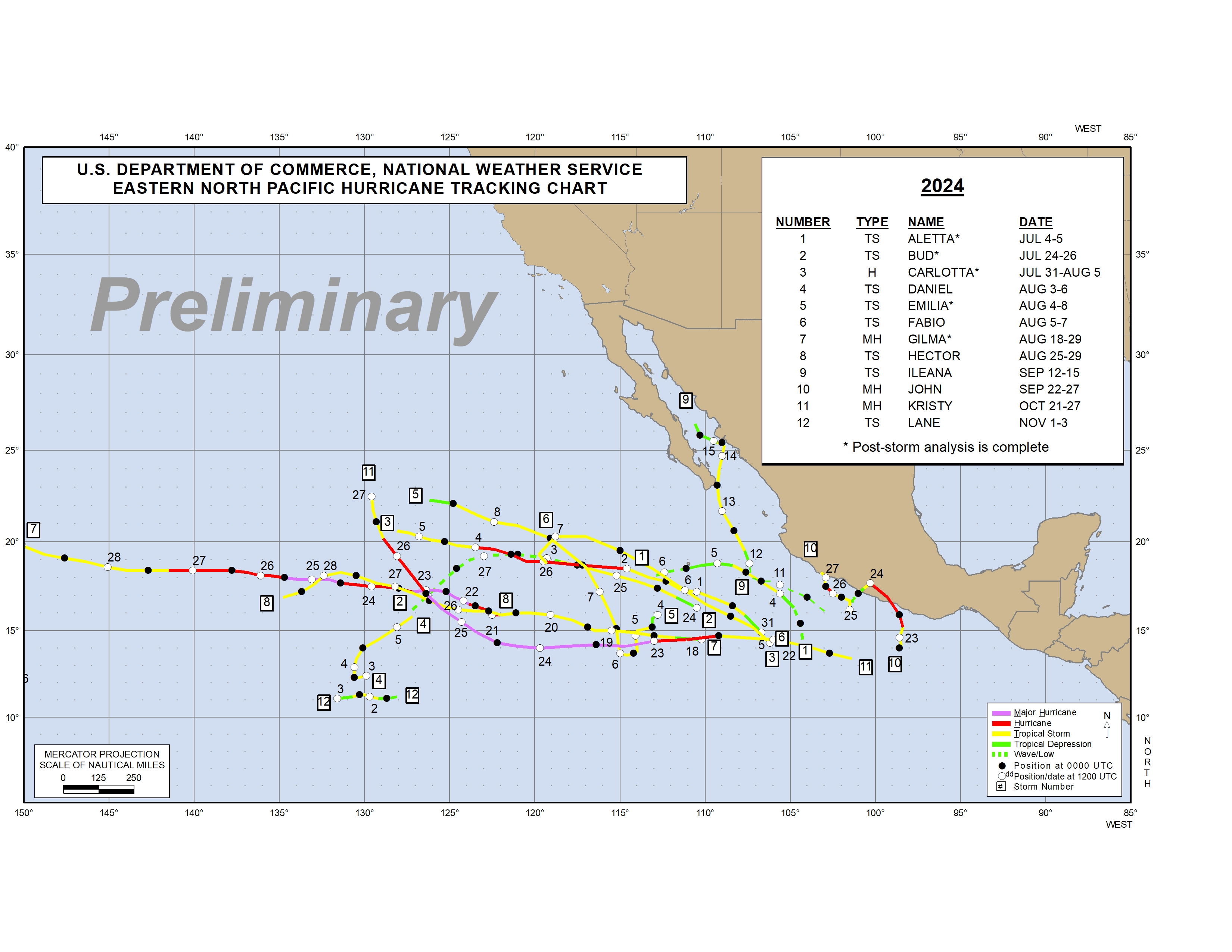
NHC Eastern North Pacific
16 June 2025
Active tropical cyclones in the Eastern North Pacific-
Eastern North Pacific Tropical Weather Outlook
000
ABPZ20 KNHC 162337
TWOEP
Tropical Weather Outlook
NWS National Hurricane Center Miami FL
500 PM PDT Mon Jun 16 2025
For the eastern and central North Pacific east of 180 longitude:
Active Systems:
The National Hurricane Center is issuing advisories on Potential
Tropical Cyclone Five-E, located in the eastern Pacific basin off
the coast of Guatemala.
* Formation chance through 48 hours...high...near 100 percent.
* Formation chance through 7 days...high...near 100 percent.
&&
Public Advisories on Potential Tropical Cyclone Five-E are issued
under WMO header WTPZ35 KNHC and under AWIPS header MIATCPEP5.
Forecast/Advisories on Potential Tropical Cyclone Five-E are issued
under WMO header WTPZ25 KNHC and under AWIPS header MIATCMEP5.
$$
Forecaster Gibbs/Cangialosi -
Summary for Tropical Depression Five-E (EP5/EP052025)
...HURRICANE WATCH ISSUED FOR PORTIONS OF SOUTHERN MEXICO... As of 9:00 PM CST Mon Jun 16 the center of Five-E was located near 11.2, -92.6 with movement WNW at 12 mph. The minimum central pressure was 1007 mb with maximum sustained winds of about 35 mph.
-
Tropical Depression Five-E Public Advisory Number 2
Issued at 900 PM CST Mon Jun 16 2025
000
WTPZ35 KNHC 170241
TCPEP5

BULLETIN
Tropical Depression Five-E Advisory Number   2
NWS National Hurricane Center Miami FL       EP052025
900 PM CST Mon Jun 16 2025

...HURRICANE WATCH ISSUED FOR PORTIONS OF SOUTHERN MEXICO...


SUMMARY OF 900 PM CST...0300 UTC...INFORMATION
----------------------------------------------
LOCATION...11.2N 92.6W
ABOUT 535 MI...860 KM SE OF PUNTA MALDONADO MEXICO
MAXIMUM SUSTAINED WINDS...35 MPH...55 KM/H
PRESENT MOVEMENT...WNW OR 300 DEGREES AT 12 MPH...19 KM/H
MINIMUM CENTRAL PRESSURE...1007 MB...29.74 INCHES


WATCHES AND WARNINGS
--------------------
CHANGES WITH THIS ADVISORY:

The government of Mexico has issued a Hurricane Watch from Bahia De
Huatulco to Punta Maldonado and a Tropical Storm Watch east of
Bahia De Huatulco to Salina Cruz.

SUMMARY OF WATCHES AND WARNINGS IN EFFECT:

A Hurricane Watch is in effect for...
* Bahia De Huatulco to Punta Maldonado

A Tropical Storm Watch is in effect for...
* Salina Cruz to Bahia De Huatulco

A Hurricane Watch means that hurricane conditions are possible
within the watch area.  A watch is typically issued 48 hours
before the anticipated first occurrence of tropical-storm-force
winds, conditions that make outside preparations difficult or
dangerous.

A Tropical Storm Watch means that tropical storm conditions are
possible within the watch area, generally within 48 hours.

Interests elsewhere in southern Mexico should monitor the progress
of this system.

For storm information specific to your area, please monitor
products issued by your national meteorological service.


DISCUSSION AND OUTLOOK
----------------------
At 900 PM CST (0300 UTC), the center of Tropical Depression Five-E
was located near latitude 11.2 North, longitude 92.6 West. The
depression is moving toward the west-northwest near 12 mph. A
slower west-northwest to northwest motion is expected during the
next few days. On the forecast track, the system is expected to
approach the coast of southern Mexico by late Wednesday.

Maximum sustained winds are near 35 mph (55 km/h) with higher gusts.
Strengthening is forecast, and the system is expected to become a
tropical storm by early Tuesday and a hurricane on Wednesday.

The estimated minimum central pressure is 1007 mb (29.74 inches).


HAZARDS AFFECTING LAND
----------------------
Key messages for Tropical Depression Five-E can be found in
the Tropical Cyclone Discussion under AWIPS header
MIATCDEP5 and WMO header WTPZ45 KNHC.

RAINFALL: Tropical Depression Five-E may produce rainfall totals of
2 to 4 inches, with maximum totals of 6 inches, across coastal
sections of El Salvador, Guatemala and the Mexican states of
Chiapas, Tabasco and Veracruz.  Rainfall totals of 4 to 8 inches,
with maximum totals of 12 inches, are possible across the Mexican
states of Oaxaca and Guerrero. This rainfall may produce life
threatening flooding and mudslides, especially in areas of steep
terrain.

For a complete depiction of forecast rainfall associated with
Tropical Depression Five-E, please see the National Weather
Service Storm Total Rainfall Graphic available at
hurricanes.gov/graphics_ep5.shtml?rainqpf

WIND: Hurricane conditions are possible in the hurricane watch area
by Wednesday night. Tropical storm conditions are possible in the
tropical storm watch area by late Wednesday.

STORM SURGE: Storm surge could produce coastal flooding near where
the center crosses the coast in areas of onshore winds. The surge
will be accompanied by large and destructive waves.

SURF:  Swells generated by the system are expected to begin
affecting the coast of southern Mexico in a day or so.  These
swells are likely to cause life-threatening surf and rip current
conditions.  Please consult products from your local weather office.


NEXT ADVISORY
-------------
Next intermediate advisory at 1200 AM CST.
Next complete advisory at 300 AM CST.

$$
Forecaster Cangialosi
-
Tropical Depression Five-E Forecast Advisory Number 2
Issued at 0300 UTC TUE JUN 17 2025
024
WTPZ25 KNHC 170240
TCMEP5

TROPICAL DEPRESSION FIVE-E FORECAST/ADVISORY NUMBER   2
NWS NATIONAL HURRICANE CENTER MIAMI FL       EP052025
0300 UTC TUE JUN 17 2025

TROPICAL DEPRESSION CENTER LOCATED NEAR 11.2N  92.6W AT 17/0300Z
POSITION ACCURATE WITHIN  30 NM

PRESENT MOVEMENT TOWARD THE WEST-NORTHWEST OR 300 DEGREES AT  10 KT

ESTIMATED MINIMUM CENTRAL PRESSURE 1007 MB
MAX SUSTAINED WINDS  30 KT WITH GUSTS TO  40 KT.
WINDS AND SEAS VARY GREATLY IN EACH QUADRANT.  RADII IN NAUTICAL
MILES ARE THE LARGEST RADII EXPECTED ANYWHERE IN THAT QUADRANT.

REPEAT...CENTER LOCATED NEAR 11.2N  92.6W AT 17/0300Z
AT 17/0000Z CENTER WAS LOCATED NEAR 11.0N  92.4W

FORECAST VALID 17/1200Z 11.8N  93.3W
MAX WIND  35 KT...GUSTS  45 KT.
34 KT... 30NE   0SE   0SW   0NW.

FORECAST VALID 18/0000Z 12.5N  94.2W
MAX WIND  45 KT...GUSTS  55 KT.
34 KT... 40NE  30SE  20SW  30NW.

FORECAST VALID 18/1200Z 13.3N  95.2W
MAX WIND  55 KT...GUSTS  65 KT.
50 KT... 20NE  20SE   0SW   0NW.
34 KT... 60NE  60SE  40SW  50NW.

FORECAST VALID 19/0000Z 14.2N  96.3W
MAX WIND  70 KT...GUSTS  85 KT.
64 KT... 10NE  10SE   0SW   0NW.
50 KT... 30NE  20SE  15SW  20NW.
34 KT... 80NE  70SE  50SW  50NW.

FORECAST VALID 19/1200Z 15.5N  97.4W
MAX WIND  80 KT...GUSTS 100 KT.
64 KT... 20NE  20SE   0SW  10NW.
50 KT... 30NE  30SE  20SW  30NW.
34 KT... 60NE  70SE  50SW  50NW.

FORECAST VALID 20/0000Z 16.6N  98.7W...INLAND
MAX WIND  50 KT...GUSTS  60 KT.
50 KT...  0NE  20SE  20SW   0NW.
34 KT... 40NE  60SE  60SW  40NW.

EXTENDED OUTLOOK. NOTE...ERRORS FOR TRACK HAVE AVERAGED NEAR 100 NM
ON DAY 4 AND 125 NM ON DAY 5...AND FOR INTENSITY NEAR 15 KT EACH DAY

OUTLOOK VALID 21/0000Z 18.3N 101.3W...POST-TROP/INLAND
MAX WIND  20 KT...GUSTS  30 KT.

OUTLOOK VALID 22/0000Z...DISSIPATED

REQUEST FOR 3 HOURLY SHIP REPORTS WITHIN 300 MILES OF 11.2N  92.6W

INTERMEDIATE PUBLIC ADVISORY...WTNT35 KNHC/MIATCPEP5...AT 17/0600Z

NEXT ADVISORY AT 17/0900Z

$$
FORECASTER CANGIALOSI
-
Tropical Depression Five-E Forecast Discussion Number 2
Issued at 900 PM CST Mon Jun 16 2025
000
WTPZ45 KNHC 170242
TCDEP5

Tropical Depression Five-E Discussion Number   2
NWS National Hurricane Center Miami FL       EP052025
900 PM CST Mon Jun 16 2025

Geostationary satellite and microwave images indicate that the
system has developed a well-defined circulation, and deep convection
has been consolidating near and north of the center. Therefore, the
system now meets the criteria of a tropical depression. The initial
intensity remains 30 kt based on the latest Dvorak estimates from
TAFB and SAB.

The depression is moving west-northwestward at 10 kt. A slower
west-northwestward to northwestward motion is expected during the
next few days as the ridge currently steering the system weakens.
Although the models are in fair agreement, the complexity of the
track moving parallel to the coast of southern Mexico means that
small changes in the system's heading will cause notable differences
on where and when the most significant wind impacts will occur.
The NHC track forecast lies near the middle of the guidance
envelope and is generally similar to the previous one. Users are
reminded that the average 60-hour NHC track error is a little more
than 60 n mi.

The environmental conditions are nearly ideal for intensification
with the vertical wind shear expected to be less than 10 kt,
mid-level humidities near or above 80 percent, and SSTs over 29
C for the next 2 or 3 days. Nearly all of the models show the
system strengthening significantly, and given the conducive
conditions, rapid intensification is a possibility. The NHC
intensity forecast lies near the consensus models and shows the
cyclone becoming a tropical storm by early Tuesday and a hurricane
before it reaches Mexico.

Based on this forecast, a Hurricane Watch has been issued for
portions of southern Mexico. Watches will likely be extended
westward on Tuesday.


KEY MESSAGES:

1. The depression is expected to become a tropical storm by early
Tuesday and quickly strengthen into a hurricane by Wednesday as it
approaches southern Mexico. A Hurricane Watch has been issued for
portions of southern Mexico.

2. The depression will likely produce heavy rainfall across
portions of Central America and southern Mexico through this week.
Life-threatening flooding and mudslides are possible, especially in
areas of steep terrain.

3. Storm surge could produce coastal flooding near where the center
crosses the coast.


FORECAST POSITIONS AND MAX WINDS

INIT  17/0300Z 11.2N  92.6W   30 KT  35 MPH
 12H  17/1200Z 11.8N  93.3W   35 KT  40 MPH
 24H  18/0000Z 12.5N  94.2W   45 KT  50 MPH
 36H  18/1200Z 13.3N  95.2W   55 KT  65 MPH
 48H  19/0000Z 14.2N  96.3W   70 KT  80 MPH
 60H  19/1200Z 15.5N  97.4W   80 KT  90 MPH
 72H  20/0000Z 16.6N  98.7W   50 KT  60 MPH...INLAND
 96H  21/0000Z 18.3N 101.3W   20 KT  25 MPH...POST-TROP/INLAND
120H  22/0000Z...DISSIPATED

$$
Forecaster Cangialosi
-
Tropical Depression Five-E Wind Speed Probabilities Number 2
Issued at 0300 UTC TUE JUN 17 2025
000
FOPZ15 KNHC 170241
PWSEP5

TROPICAL DEPRESSION FIVE-E WIND SPEED PROBABILITIES NUMBER   2
NWS NATIONAL HURRICANE CENTER MIAMI FL       EP052025
0300 UTC TUE JUN 17 2025

AT 0300Z THE CENTER OF TROPICAL DEPRESSION FIVE-E WAS LOCATED NEAR
LATITUDE 11.2 NORTH...LONGITUDE 92.6 WEST WITH MAXIMUM SUSTAINED
WINDS NEAR 30 KTS...35 MPH...55 KM/H.

Z INDICATES COORDINATED UNIVERSAL TIME (GREENWICH)
   PACIFIC  DAYLIGHT TIME (PDT)...SUBTRACT 7 HOURS FROM Z TIME
   HAWAIIAN STANDARD TIME (HST)...SUBTRACT 10 HOURS FROM Z TIME

WIND SPEED PROBABILITY TABLE FOR SPECIFIC LOCATIONS

CHANCES OF SUSTAINED (1-MINUTE AVERAGE) WIND SPEEDS OF AT LEAST
  ...34 KT (39 MPH... 63 KM/H)...
  ...50 KT (58 MPH... 93 KM/H)...
  ...64 KT (74 MPH...119 KM/H)...
FOR LOCATIONS AND TIME PERIODS DURING THE NEXT 5 DAYS

PROBABILITIES FOR LOCATIONS ARE GIVEN AS OP(CP) WHERE
    OP  IS THE PROBABILITY OF THE EVENT BEGINNING DURING
        AN INDIVIDUAL TIME PERIOD (ONSET PROBABILITY)
   (CP) IS THE PROBABILITY OF THE EVENT OCCURRING BETWEEN
        00Z TUE AND THE FORECAST HOUR (CUMULATIVE PROBABILITY)

PROBABILITIES ARE GIVEN IN PERCENT
X INDICATES PROBABILITIES LESS THAN 1 PERCENT
PROBABILITIES FOR 34 KT AND 50 KT ARE SHOWN AT A GIVEN LOCATION WHEN
THE 5-DAY CUMULATIVE PROBABILITY IS AT LEAST 3 PERCENT.
PROBABILITIES FOR 34...50...64 KT SHOWN WHEN THE 5-DAY
64-KT CUMULATIVE PROBABILITY IS AT LEAST 1 PERCENT.


  - - - - WIND SPEED PROBABILITIES FOR SELECTED LOCATIONS - - - -

               FROM    FROM    FROM    FROM    FROM    FROM    FROM
  TIME       00Z TUE 12Z TUE 00Z WED 12Z WED 00Z THU 00Z FRI 00Z SAT
PERIODS         TO      TO      TO      TO      TO      TO      TO
             12Z TUE 00Z WED 12Z WED 00Z THU 00Z FRI 00Z SAT 00Z SUN

FORECAST HOUR    (12)   (24)    (36)    (48)    (72)    (96)   (120)
- - - - - - - - - - - - - - - - - - - - - - - - - - - - - - - - - -
LOCATION       KT

MANZANILLO     34  X   X( X)   X( X)   X( X)   X( X)   3( 3)   X( 3)

L CARDENAS     34  X   X( X)   X( X)   X( X)   3( 3)   9(12)   X(12)
L CARDENAS     50  X   X( X)   X( X)   X( X)   X( X)   4( 4)   X( 4)
L CARDENAS     64  X   X( X)   X( X)   X( X)   X( X)   1( 1)   X( 1)

ZIHUATANEJO    34  X   X( X)   X( X)   X( X)   6( 6)  10(16)   X(16)
ZIHUATANEJO    50  X   X( X)   X( X)   X( X)   1( 1)   4( 5)   X( 5)
ZIHUATANEJO    64  X   X( X)   X( X)   X( X)   X( X)   2( 2)   X( 2)

15N 100W       34  X   X( X)   1( 1)   3( 4)  15(19)   3(22)   X(22)
15N 100W       50  X   X( X)   X( X)   X( X)   2( 2)   1( 3)   X( 3)

ACAPULCO       34  X   X( X)   X( X)   2( 2)  26(28)   5(33)   X(33)
ACAPULCO       50  X   X( X)   X( X)   X( X)   6( 6)   5(11)   X(11)
ACAPULCO       64  X   X( X)   X( X)   X( X)   2( 2)   2( 4)   X( 4)

P MALDONADO    34  X   X( X)   1( 1)   7( 8)  46(54)   2(56)   X(56)
P MALDONADO    50  X   X( X)   X( X)   1( 1)  22(23)   2(25)   X(25)
P MALDONADO    64  X   X( X)   X( X)   X( X)   7( 7)   2( 9)   X( 9)

P ANGEL        34  X   1( 1)   4( 5)  35(40)  32(72)   1(73)   X(73)
P ANGEL        50  X   X( X)   X( X)   6( 6)  22(28)   X(28)   X(28)
P ANGEL        64  X   X( X)   X( X)   2( 2)   6( 8)   X( 8)   X( 8)

HUATULCO       34  X   X( X)   1( 1)  11(12)  22(34)   1(35)   X(35)
HUATULCO       50  X   X( X)   X( X)   1( 1)   4( 5)   1( 6)   X( 6)

10N 95W        34  X   2( 2)   1( 3)   2( 5)   1( 6)   X( 6)   X( 6)

15N 95W        34  X   2( 2)  16(18)  26(44)   6(50)   X(50)   X(50)
15N 95W        50  X   X( X)   1( 1)   6( 7)   2( 9)   1(10)   X(10)
15N 95W        64  X   X( X)   X( X)   2( 2)   X( 2)   X( 2)   X( 2)

SALINA CRUZ    34  X   X( X)   X( X)   2( 2)   1( 3)   X( 3)   X( 3)

P SAN JOSE     34  X   1( 1)   1( 2)   1( 3)   1( 4)   X( 4)   X( 4)

$$
FORECASTER CANGIALOSI